O’Leary Mountain Trail
Trail Snapshot:
Trail Description
E-bikes NOT allowed on O’Leary Mountain
Beginning at O’Leary / Castle Rock Trailhead, O’Leary Mountain Trail #3321 heads east, switching back steeply up a large ridge through an old growth conifer forest. The trail continues uphill, following Forest Road 3321 until it passes below a panaroramic viewpoint on Macduff Mountain. Passing the mountain, the trail drops into a saddle, then sidehills east below McLennan Mountain. The trail occasionally breaks out of forest into rock outcroppings, then hooks north to reach its terminus at Olallie Trail #3529.
The steep switchbacks near the West end of the trail are being re-routed currently.
Trail description from the US Forest Service website.
Most people ride this trail as part of a clockwise loop with Olallie, O’Leary, Castle Rock and King Castle. That way you can climb a significant amount of road which will get you pretty high up on the loop before decending 100% singletrack. The full loop is over 30 miles and 6000+ ft elevation — so brace for a long day.
Hit up Horse Creek Lodge & Outfitters if you are looking for a shuttle, or a guided tour of the O’Leary Mountain Trail.

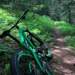


First 4+ miles had more logs across the trail than we could count and tons of debris from the winter made the ride tough; Started at Horse Pasture TH. Good progress on trail clearing once we got down past Macduff Mountain.
Rode this on 8/31/24 from Horsepasture trailhead. This trail is in serious need of some clearing! The first 5 miles of the ride (Olallie section and onto O’leary) up to McDuff Mountain were very overgrown and we had to walk quite a bit because we couldn’t see the trail and kept running into hidden rocks. If you ride this, wear pants and long sleeves, because I was covered in scratches. Mostly clear of trees. Riding great from McDuff mountain down.
All clear, but some overgrown sections between Olallie and the MacDuff summit and a few face slappers on the DH – easy trimming, but I had an afternoon appointment I needed to make.
The good news: from Macduff west everything is clear and running great. East of Macduff there are ~20 trees down, worse than it was before it got cleared last November. A few patches of snow between Macduff & Ollalie. Last report is that the road to Horsepasture is still snowed in so it could still be a while before anybody can get in there with some saws.
Riding the west section, snow starts just before McDuff mtn.
About half a dozen trees down mostly on the climb from the east toward mcduff. At least 4 which are needing a chainsaw including on directly hanging into the trail below a switchback. Many of the switchbacks on the descent are very dry/fluffy. Trail could use a good brushing.
It’s NFSR 1900411 the trail follows. 3321 is the trail number.
Sounds like lower O’Leary is clear. A few trees on the way up to macduff from the west.
Any updates on if the full O’lallie/O’leary/Kings loop is rideable? Thanks!
Started at Olallie North TH. Hit snow at FS Rd 340 (about 4800ft)…..and stayed that way till just east of Macduff. Then snow-free west of Macduff.
O’Leary Trail clear of trees west side of Macduff. Olallie Trail clear of trees up till FS Rd 340….thank you to however cleared them!
Give it another 2-3 weeks before snow has melted.
Got to within 1/2-1mile of Macduff (from west side) before hitting snow. 2 small trees down. Lots of debris.
Some snow patches but clear of downfall. Thanks Dod crews
One tree down (but it crosses the trail twice) on the way down the west side of O’Leary. Otherwise it’s golden right now.
Alyssa at horse Creek posted an update today:
“Couple of things I wanted to mention here. Air quality is great over on the McKenzie today, Saturday. Can’t make any promises as to what tomorrow holds. Also, there was some confusion about trail closures, and after talking to our local ranger, I’ve confirmed that O’Leary Loop Trail, including Olallie N. and King-Castle are open. Some of the access roads along the way are closed, however. Our District Ranger also asked that if people choose to ride, please drive cautiously and slowly up FS roads 1993 and 356, and know that if riders have to bail due to injury or mechanical, the only way out is down the trail, since most access roads are closed. Ranger station is open today, but you can also message or call us at 541-822-3243 if you have questions.”
https://www.fs.usda.gov/
from Willamette NF post:
The Scorpion Crew is energized and full of new volunteer trail stewards! Not only did one crew hike the entire East Fork Trail in the Three Sisters Wilderness another crew tackled the O’Leary Trail. The O’Leary crew got their legs and hearts pumping, starting at 3800 feet, climbing to 5000 feet, and going back down to 4600 feet. They cleared over 15 trees and filled in some large holes. They report there is still significant snow on the trail in places, varying from 10 feet to 150 long and up to a foot or more of depth.
You guys rock!!! Rode it today and it was wonderful!! Saw all the newly cleared trees and was very grateful! I didn’t see another soul until I dropped into Kings Castle. Is there a way to donate to you trail stewards! Thanks trial gods!
Good and bad news. Trail is now open. However snow at higher elevations.
Called McKenzie River Mountain Resort and they said could be open any day, but still closed as of now.
Trail is closed due to wildfire.
trees are clear and still a couple snow patches. changed status to riding well
7 trees down and a couple snow patches. Word has it that the trees may have been cleared this weekend.
We rode up O’Leary to just below the Macduff mountain high point before descending via Castle Rock and King Castle. There was no snow or deadfall to be found up to our turnaround point, which according to the map is maybe half way up?
Climbing up O’Leary is really hard. I’m tired. Good night.
Man, hats off to whomever put in the work on the trail. My first time riding it but I could see the new vs old and what an excellent job.
1 tree down today, but damn the new trail work is ridonk! So good.
This trail was wonderfully damp yesterday. Met two FS fellas who have done most of the trail work around O’leary. They are doing a great job! They said they are trying to get all trail work done before a mountain bike race on October 2, which I cannot find the name of. Does anyone know?
Looks like this: http://trans-cascadia.com/
No trees down but still hard work getting down in some places. Looks like the rerouting trailwork is taking place, but still have to walk several loose, tight switchbacks. Otherwise perfect conditions with the zippity do dah downhill ending (nice reroute on Castle Rock!) and the wildflowers are peaking!