Browse The Trails
Expand Map Expand Page

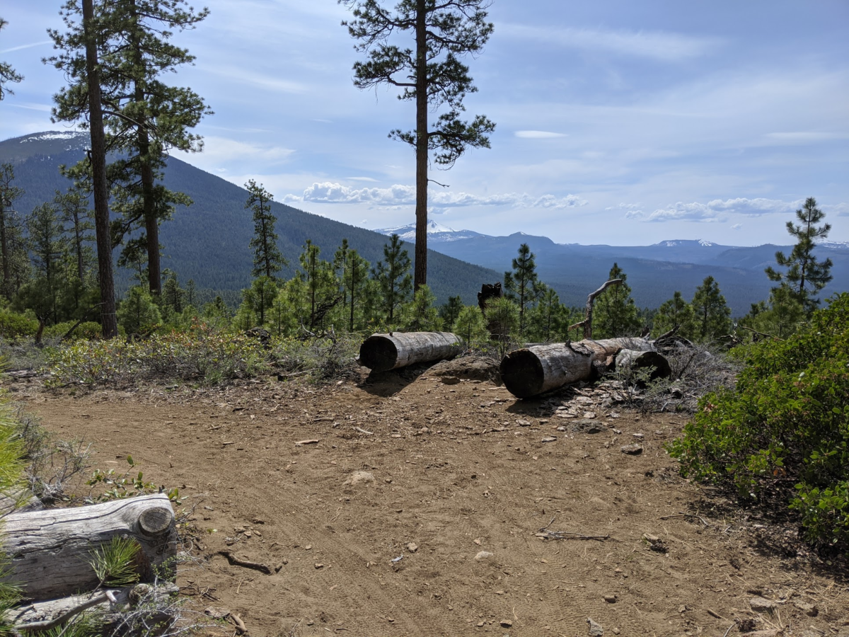
Green Ridge Trail
Trail Snapshot:
Trail Description
E-bikes NOT allowed on Green Ridge
The Green Ridge Trail is a ridgeline ride high above the Metolius River. Views of Jefferson and 3 Fingered Jack are amazing. The trail itself is a mix of singletrack and double track. Use is light, and you might see horses or ATVs on any single ride. Much of the forest along this trail was burned so views are better now than that once were.
Trail Photos


CONNECT WITH BEND TRAILS
©2026 MTB Trails LLC, All Rights Reserved
A Project of Sketchbook Inc. and Delicious

Green Ridge was cleared of deadfall on June 14
Rode the entire trail (from the TH on FR1120 to the far northern TH past the lookout) on 6/8. Overall it was a spectacular ride and I’m glad I did it! If you don’t like lifting your bike over logs, forget it. There are still a lot (at least 15-20 without ride-arounds). But if you just take that in stride, there are also plenty of log-free stretches that are fantastic. There are places where the singletrack trail merges with a doubletrack, which is fine. And while the views are great throughout, the best views are from the northern end past the lookout (so if you turn around before then you missed them). Not wanting to repeat all the log hauls, I did this ride as a 30-mile loop, taking the dirt road from the northern TH down to paved Metolius River Road, and then back to where I started from there. Doing this makes for a very long day, but it’s an epic ride!
Lots of trees down from both north and south entrance. Would not currently recommend.
Hi Arthur – cota/TKO will be clearing this trail June 5-6 as part of a chainsaw class. Pretty please nobody clear these trees. We need them for evaluating sawyers. Cheers
Trail is riding great from start to end ! I’m not going to override the last report, but it is not ‘sandy or loose’ :) There are maybe half a dozen trees down the entire length, and all but one have ride-arounds
The lookout was closed, so we rode the whole trail (it goes about two miles north of the lookout) and cut out the remaining deadfall. A little dry, but not too bad.
Rode the entire top part along the ridge. Fun new single track on the Southern end. Occasional deadfall throughout, but nothing major until you hit the last 2 mile section, which has numerous snags, including a large one in the middle of that section (in the usual spot :). Several 12″ trees. Also a massive one blocking the entrance on the North side.
Still a lot of unridable snow patches and downfall up on the ridge. The south end of the ridge and downhill were affected by last year’s fire. Trail repair/reroute is in process. It needs some time and love.
The Green Ridge Fire is 1,013 acres burning on the Deschutes National Forest and private land protected by the Oregon Department of Forestry. A Type 2 Incident Management Team has taken command of the fire and the Deschutes and Jefferson County Sheriff’s Offices issued a joint notice for evacuation levels on the Green Ridge Fire. More information can be found here.
What a gem of a trail with epic views! Especially like the last few miles after the lookout. Looks like someone recently cut, but there are still probably 10 trees down, mostly in that last section through the burn – worthy of a chainsaw.
Rode from road 1120 to 8 miles in before turning back (there are 2 large blowdowns at the 8 mile mark, looks like they’ve been there some time. Easy enough to dismount and lift your bike over). There are only a couple other blowdowns before this, all easy to ride over or around. There are some sandy bits here and there, watch those corners coming down! Otherwise it was quite enjoyable with beautiful views. Saw 2 hikers, 2 bikers, 1 equestrian, and 2 ATVs right where the single track turns onto the old road up on the ridge.
Rode from the 1120 TH to Green Ridge lookout and back on 4/10/2020. A little bit of additional blowdown compared to late Oct 2019 but not bad. Many patches of snow to cross above 4500′. Some you can ride through with 2.5″ tires but most not. I’d suggest waiting for more snow melt.
Greg, thanks for the report on GR. Could you comment further on those three logs – were you able to get around them fairly easily? At this point we may have to leave them until spring.
Hi Patrick … sorry, just saw your post. No problems getting around/over these logs.
Rode from TH on Rd 1120 to GR lookout and back – about 19 miles. Good aerobic workout up and fun downhill return. Very nice conditions – damp trail, no dust. No signs of recent use. There are 3 logs over trail, 14-20″ diameter, all located between 5-8 miles in from the TH.
Top (northern) two miles of Green Ridge was logged out by STA on June 18th. About 30 trees.
‘Whole length down to Road 1120 should be clear now but but for one on the south end. There are still significant patches of aggressive Ceanothus (Snow Brush) growth.
Note: alignment of the currently used track for Green Ridge Trail is significantly different than shown on the old National Geographic 819 Mount Jeff map and also on many other maps. Work is underway to improve the routing, signage and GPS mapping over time. STA’s 2019 map is the most accurate although it shows one section to be open that is not yet complete – the 1-mile segment that is shown east of Road 600 and the GR Lookout. For now use Road 600 for that section – roughly 1 mile south of the Lookout, the trail takes off to the west of Road 600. from thee south the route is more easily followed.
Thanks Patrick. We received the GPS file for this trail via the USFS sisters district. If you have a better alignment can you email it to us? bendtrails@mtb-trails.org.
Almost no sign of horses from the Allingham Cutoff TH to the lookout tower. More sign of motorized use once on the ridge. At least two miles of double track to reach the lookout. A little bit of bushwhacking encroaching snowbush. There is a two foot log across within a quarter mile of the start which was pushed in the way when obliterating a road crossing. This is not a flow trail. More point and shoot on the discent. Lots of flowers and snow capped peaks.
Hey Bruce, could you verify the location of that 2 footer? Is it just at the beginning of the uphill traverse or further up the hill? Thanks in advance
Yes, at the beginning of the traverse to the south.
Worth noting the log is partially laying parallel to the trail so likely a more difficult removal.
Thanks
Bruce, Thanks for your report on Green Ridge. As mention we logged out the top 2 miles while ago but hadn’t had a chance to scout the big log you noted in the trail at the south end, until yesterday. Yes, I think you are right that it was dragged in there by the decommissioning crew! Not cool. We’ll get it cleared soon.
Most of the trail’s in great shape, with very little horse traffic. Only trees down are in the last 2 miles, with a big snag in the burn about a mile from the end (same spot as last year), and a few others here and there. Some moto damage still evident in that last section. Maybe there’s a way to leave enough trees to deter them ?
Thanks Marc! We (STA) will organize a work party to clear this. Particularly useful to know there are no windfall issues on the southern section. If you don’t mind, a clarification… we knew about one big log just a few hundred feet from the north end of the trail (of the northernmost section). But this is not the big snag you referenced, right? It is about one mile in?? Any chance you can estimate the diameter of that one so that we can carry the right-sized chainsaw. Much appreciated, Patrick
I actually didn’t ride the last half-mile of that northern section (too tired after 8 hours of riding:), so didn’t see that big one you’re talking about. The snag is about in the mid-point of that last 2-mile section. There’s a burn it goes thru there, and there were 8-10 trees of varying width down there (I don’t recall anything larger than a foot in diameter)
Thanks much!
June 28th Update – Green Ridge Trail is now fully open with no obstructions. Just a few areas of aggressive Ceanothus… and some bumpy horse tracks. 11 trees were removed today and some temporary flagging put up to direct users to the route (a little hard to see in places).
Sadly, after just finishing the clearing of the northern 2 miles of the system last Wednesday, some motorcycles got in over the last two days and did some real damage!! Grrrr
Thanks Marc Fortier for sending us a GPX file of the corrected North end of the Green Ridge trail. It’s updated on all the maps.
June 25, 2018 UPDATE – GR Trail Open with just a few trees still down, interspersed along the whole southern 10-mile section. Thanks to Marc Fortier’s earlier report of his May 28th ride, our STA work crew for last Wednesday was able to prioritize re-opening the newer 2-mile northern segment of the GR Trail that Marc highlighted as in need of clearing… (this section starts just north of the Fire Lookout gate off FS 1140-600 and ends at the new official north terminus of the GR Trail on the spur road FS 1490-900.) We cleared 31 downed trees, brushed and marked obscured sections with flagging tape and cairns. Happy to report that this northern section is now completely open and much easier to follow. It’s a really nice route with some stunning views to the west. Until it get’s ridden and worn in a bit more, some parts will remain a little hard to follow but look for orange or pink flagging tape and cairns (note there is some confusing old blue flagging in a couple of places – just ignore). The southern section is next for clearing and there is an ongoing effort to brush that route over the next couple of weeks – crazy ceanothus!
I should mention that STA’s new 2018 trails paper map includes a scannable QR code for loading our new georefferenced PDF map that combines our north and south paper maps and has been extended north as far as the GR Trail’s northern trailhead an FS 1490. Sorry, I don’t know how to forward or attach the link on this platform.
Awesome Patrick ! Thanks for taking care of that beautiful section. I usually only ride it once a year, but now will have to get back there to test it out !
Riding great, with 10-12 trees down over the entire length, nothing too troublesome. There’s a 2 mile section to the North that’s not on this map, and I last rode cleanly in 2015. I made it about 3/4 of the way through from the Northern end, before hitting a second long deadfall section, and then gave up as I was running out of time. But I hacked through the first deadfall section as best I could with my hand saw. There’s some spectacular views on this part, possibly the best of the entire trail. Nature’s working hard to reclaim it, but the tread is mostly still there. Needs some big saw work !
Marc, any chance you could call me to provide a few more details on the location of downed trees on this trail. A small group of STA volunteers is considering a log-out tomorrow (Wednesday). My number is 541-639-2333 – Patrick
What a gorgeous trail! OK, the trail itself is not that awesome, but the views, wilderness and wildflowers more than makeup for it! Definitely get yourself to the lookout!!
An FYI: I tracked my ride w/ GPS, Gaia, and Ride with GPS. (I know, overkill, but trying to see what works best.) This ride, following the yellow diamonds, does NOT jive with what Gaia and NW Topo call the Green Ridge Trail. They’re close to parallel, but definitely not the same.
Riding good. Definitely needs some clearance work, some has been done. Notably, encroaching Snowbrush in high speed areas….will try to get out and clear soon. Little to no horse traffic!!
Hi – any clearing updates ? Planning on heading there this weekend. Is the section past the lookout still mostly abandoned ?
This was my first time out there. Riding nicely….a few horse tracks for a couple miles then nice to the lookout. It is key to go with someone who has ridden it or if you’ve ridden it before. There are quite a few unmarked turns and other FS roads to get confused on.
Rains just hit this hard and washed the trail clear, I think its going to be good until the horses chop it up again. Brown Powder!
This is a shared use trail, the lower section of which, if started at metolius headwaters on trail 99 is dusty, dry, and miserably chopped up by horse hooves. In fact, trail 99 around black butte is miserable for bikes. Don’t miss the green ridge trail junction on trail 99 at a small, weathered sign on a dirt road. Bring a reliable map. Once most of the steep climbing is done, when views of black butte and the cascades can be had, the frequency of downed trees increases and the trail becomes less and less traveled and more and more narrow. Pine cones litter the trail, making a bumpy ride with multiple dismounts for downed trees. Some trees can be ridden around through brush and soft dirt. Trail signs seem to disappear around FS road 850 or 798 but if one rides along an un-numbered road near the ridge line, a nice break from the incessant trail chatter can be had and views of the Cascades through lush and flowery forests and burned trees abound. I ran out of trail seeking time when I got to FS road 566 and was weary of horse chop anyway and so made the return trip to my car at the beautiful Metolius Headwaters. I probably won’t ride this trail again until next year, before the equestrians ruin the lower section on trail 99 and while it is still damp. Maybe the green ridge will be better maintained next year although if that happens, likely also will more horse traffic. Can’t win. Enjoyed the forest though as it’s quite delightful at this time of year.
Curious as to why your experience was so different from mine, even though you were there only a few days later. Maybe a herd of horses went through in between ? I was on a hardtail, though it was 27.5+, and found the trail a bit bumpy but not ‘miserable’ :)
Rode lower part and a portion of the upper ridge. Trail is in great shape if you don’t mind a little horse traffic. I encountered around 8 equestrians and no bikes on a Sunday. Reports of blowdown and navigation issues on the Northern part of the trail past the lookout