Hardesty Trail
Trail Snapshot:
Trail Description
E-bikes NOT allowed on Hardesty
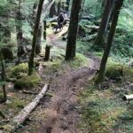
Hardesty can be climbed to access EULA Ridge or ridden downhill as a shuttle, out-and-back, or loop. While the trail is not particularly technical it does offer plenty of exposure in places, and sometimes the switchbacks are preceded by steep run-ins to test your bike-handling skills.
Sometimes you’ll be riding next to massive fir trees that tower to the sky, other times you’ll pop into open meadows that plunge to the rivers below. Just when you get into a groove you’ll hit a switchback, so keep your head up. As the trail descends the grade begins to soften and you’ll go from death-gripping the bars to feeling the flow.
At the bottom you’ll connect with the Lower Goodman Trail before connecting to Highway 58.


soupy and some sections have big holes which are muddy or just dug out and need some kind of fill.
one 20” log ¼ mile above the South Willamette intersection. Otherwise clear and accessible from the top.
Trail is now open
Closed currently due to fires